
The changing landscape of Durango, Colo.,
as seen in aerial postcard views, etc.
An activity guide for middle school students
| The CDP (formerly the Colorado Digitization Program) is supported through a National Leadership Grant to the University of Denver Penrose Library from the Institute of Museum and Library Services (a federal grant-making agency in Washington, D.C., which fosters innovation, leadership and a lifetime of learning, by supporting museums and libraries) with additional assistance from the Colorado State Library, and the Colorado Regional Library Systems. |
Intended Level: Grade 7
Subject: Social Studies
Time: Two fifty-minute periods
Focus: Students will learn how to analyze and interpret primary source postcards ... and will answer three questions:
- Why was Durango settled at this particular location?
- Why was it settled in 1891?
- Why has the city grown and thrived, whereas other 1890s settlements (Hesperus, Rico) have not?
Standard Assessed:
Geography 1: Students know how to use and construct maps, globes, and
other geographic tools to locate and derive information about people, places,
and environments.
1.1 Students know how to use maps, globes, and other geographic tools
interpret and construct maps, globes, models, charts, and geographic databases
1.2 Students develop knowledge of Earth to locate people, places, and environments
Identify and locate physical and human features in their own and nearby communities, in the United States, and in regions of the world
1.3 Students know how to analyze the dynamic spatial organization of people, places, and environments.
Explain different land use patterns in urban, suburban, and rural areas
Standard Addressed:
History 2: Students know how to use various processes and resources of
historical inquiry.
2.3 Students know how to interpret and evaluate primary and secondary sources of historical evidence.
Interpret the data in historical maps, photographs, works of art, and other artifacts
Assessment:
Students will create a historical map that illustrates the changes in the
landscape of the city of Durango, Colorado, from the early 1900s to the
mid-1900s. The historical map will include the initial boundaries of the
city, and its current boundaries. Students will also describe the
essential aspects of commercial and residential growth in the area. In addition to the map,
students will answer three questions that analyze the data presented that
reveals the causes for the settlement of Durango in the 1890s and its growth
into the 21st century. (See Day 2 procedure)
Materials:
- 11" X 17" blank paper for historical maps, one for each student
- Colored pencils
- Black marker
- Handouts
Support Materials:
Select from the following images, copies (4 postcards per group, and 1 of each other type of image) for each group of four students:

- Tips for dating U.S. postcards:
http://www.fortlewis.edu/finding_aids/images/M194/PostcardDating.htm
- Brief history of Durango: http://swcenter.fortlewis.edu/inventory/UsfSanJuanTCP.htm#Durango
- 1877 Hayden Survey Map of Southwest Colorado: http://www.fortlewis.edu/finding_aids/images/C004/C00409.htm
- Map of Southwest Colorado railroads: http://www.fortlewis.edu/finding_aids/images/P001/P001301152Page.htm
- Historical chronology:
http://swcenter.fortlewis.edu/FLC_Guide/FORT_LEWIS_CHRONOLOGY.htm
- 1907 Durango U.S.G.S. topographic map: http://www.fortlewis.edu/finding_aids/images/C007/C007Durango1902.htm
- 2003 Durango map: choose a map at GIS Mapping from http://gis.durangogov.org/website/
- Historical map rubric and assessment questions
Possible Procedures:
Day 1:
1. Divide students into groups of four. Explain to the class that they are
going to be looking at some postcards and other images and will need to find clues
that will help them decide approximately when these postcards etc. were
produced and also when the photos (including those used for these postcards) were taken. Mention
that clues could be found in the land, signs, the built environment, and
automobile styles. Divide the postcard images among the groups (i.e., for a
class of 24, there will be 6 groups and each group will have responsibility for
dating 4 postcards). After about 10 minutes, ask the groups what they have
discovered. Ask the following questions:
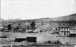
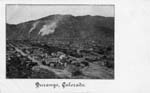
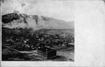
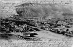
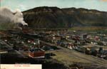
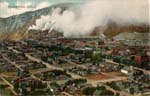
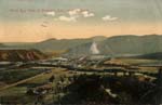
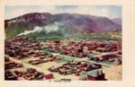
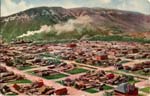
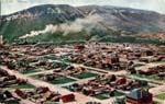
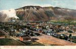
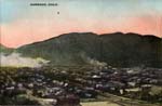
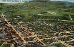
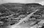
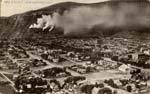
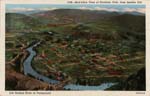
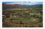
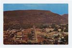
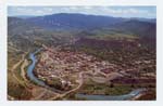
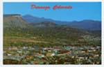
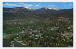
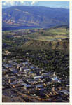
- From what vantage point in Durango do you think this was taken? In
which direction was the photographer facing? (Smelter Mountain --
billowing smoke when the smelters were operating -- is to the southwest of the
city; College Mesa is to the southeast of the city; the train station is at
the south end of Main Avenue)
- Can you date the automobiles?
- Do you recognize local landmarks in these views? (County Courthouse,
East 3rd Avenue, Greenmount Cemetery, Fort Lewis College campus)
- What are the "constants" in the built environment you see in these panorama views? (locomotive smoke; trees; orderly rectangular layout of the streets) What are the changes over the years? (no more smelter smoke; increase in built structures; increase in the foliage)
2. Next, look at the back of each postcard. Using the guidelines for dating postcards, determine the clues for refining the dating of these cards.
3. Have the students look at the historical chronology and the handout about the history of Durango. Using the metadata (bibliographic information) that accompanies each postcard, talk about the reasons why Durango was founded and how those uses changed during World War II and the Cold War. (the proximity of coal and water for smelting ore from Silverton and other mining towns in the San Juan Mountains, using the system of narrow-gauge railroads that were built in the 1880s) Tell the class that the first Environmental Protection Agency uranium mill tailings cleanup site was here in Durango at the base of Smelter Mountain. (those records are at the Center of Southwest Studies -- described on the Web at http://swcenter.fortlewis.edu/inventory/Umtra.htm )
4. Use these photos to conduct a class discussion about the time period depicted (the 20th century) and about how things have changed (building construction, transportation systems, cars, awareness of environmental issues such as air pollution and radioactive waste from smelters; and the landscape).
Day 2: Assessment
Students will use the information they learned about the history of Durango to
create a historical map for the assessment. Students may work in their groups
but each student needs to create his/her own map.
1. Review with students the basic requirements of all map-making (title, key,
and compass rose). Review the purpose of historical maps and tell students
that their maps will show the changes in Durango.
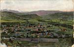
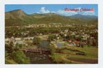
2. Hand out the historical map rubric, Photo 1, and a copy of the current
Durango map to each student group.
3. Help the class determine the two perpendicular roads that are shown in
post card 1 (Sixth Avenue) so that they have landmarks to help determine
location. To help students get started, suggest that they draw in these two roads and the
physical features of the foothills. Then they need to represent boundaries of
the city in its early days and its current boundaries. Remind
them that different colors can show this and that their key will need to explain
what they have done. See Rubric for requirements.
3. For the written assessment, students need to answer the following questions
(see historical map rubric):
- Why was Durango settled at this particular location?
- Why was it settled in 1891?
- Why has the city grown and thrived, whereas other 1890s settlements (Hesperus, Rico) have not?
|
Behind the Scenes Issue Number 3, September 2003 The Center of Southwest Studies is a division of Fort Lewis College charged with gathering, preserving, and making available for use historical and ethnographic materials pertaining to the College, the Southwest, and Native Americans of the Southwest.
|
For information regarding image access at the Center, contact:
|
Sources
used:
http://www.cdpheritage.org/educator/landscape.html
and
http://www.cdpheritage.org/educator/index.cfm
The collections are located at the Center of Southwest Studies on the campus of Fort Lewis College. Interested researchers should phone the archivist at 970/247-7126 or send electronic mail to the archivist at archives@fortlewis.edu or click here to use our E-mail Reference Request Form (or phone the archivist at 970/247-7126). The Center does not have a budget for outgoing long-distance phone calls to answer reference requests, so please email if you wish to receive a response from the Center. To request reproductions/copies, click here for instructions.
Page revised: January 24, 2008