Collection C 001: |
© 2005 by Fort Lewis College Foundation, Center of Southwest Studies account (updated 2008)
Links to contents
Scope and contents |
||||
Introduction/ Scope and contents
Southwest maps
Years this material was created: 1852-2000s (bulk 1940-1990s)
Quantity: hundreds of maps, in 23 map case drawers
This is a diversified collection of maps, of miscellaneous origin, regarding the Four Corners region (Arizona, Colorado, New Mexico, and Utah) and surrounding area of the Southwestern United States. Topics include history, Indian settlements, geology, transportation, etc. The maps are arranged by these and other broad topics. The collection includes a Southwestern Colorado expedition map, circa 1874-75.
Administrative information
Arrangement note:
The maps are arranged topically/geographically by
broad categories -- beginning with maps of Durango and moving concentrically
outward geographically from Durango into La Plata County, southwest Colorado,
Colorado, the Four Corners, and the Southwest.
Acquisition information:
This is what is commonly known as an artificial collection -- comprised
of acquisitions (primarily by gift) from various sources. Accession
numbers include 1984:11001, 1988:06007, 1990:09005, 1992:0101, 1992:1207,
1993:1105 and many others.
Processing information:
Center of Southwest Studies student workers/Fort Lewis College students
Stephanie Zuni and Brad Stapleton assisted with the arrangement of these
maps in the years 2004-2005 under the supervision (and with the assistance) of archivist Todd Ellison. This work included
humidifying rolled maps to relax and flatten them, and placing everything in
archival-quality enclosures. Archival volunteer Bruce Howard continued the
organization in 2007 and entered the data into the Center's Microsoft Access
SWMaps.mdb database, which is the source for detailed management of this
collection. This inventory was prepared by J. Todd
Ellison, last revised February 20, 2008.
Series description
The items in this collection are in a single series of maps, organized first geographically, followed by maps that lend themselves better to a topical grouping. Thus, the overall organization of these maps is by geographic name, moving from the most local maps (of the city of Durango) to the broadest (United States). Subject-based maps follow the geographically-arranged maps.
Links to sections of this list:
| Durango | La Plata County | Other Southwest Colorado |
|
| BLM |
|
|
|
|
|
|
|
Map categories:
|
Map case drawer number |
Call number |
Drawer contents description |
|
2:1 |
C001 |
Durango maps/blueprints |
|
2:2 |
C001 |
Durango tourist maps/drawings |
|
2:3 |
C001 |
Durango maps/blueprints |
|
2:4 |
C001 |
Durango maps/blueprints |
|
2:5 |
C001 |
Durango maps/blueprints |
|
2:6 |
C001 |
Durango maps/blueprints |
|
2:7 |
C001 |
Durango maps/blueprints |
|
2:8 |
C001 |
La Plata County maps/blueprints |
|
2:9 |
C001 |
La Plata County maps/blueprints |
|
2:10 |
C001 |
La Plata County maps/blueprints |
|
2:11 |
C001 |
Other Southwest Colorado maps/blueprints |
|
2:12 |
C001 |
Other Southwest Colorado maps/blueprints |
|
2:13 |
C001 |
Other Southwest Colorado maps/blueprints |
|
2:14 |
C001 |
Other Colorado maps/blueprints |
|
2:15 |
C001 |
Other Colorado maps/blueprints |
|
2:16 |
C001 |
U.S. Bureau of Land Management maps of Arizona and Colorado |
|
2:17 |
C001 |
|
|
2:18 |
C001 |
United States maps |
|
2:19 |
C001 |
U.S. Bureau of Land Management maps of California, Nevada, Utah |
Selected digital images/ itemized description of maps (this is a work in progress; we add newly digitized Southwest maps to this page, so visit this site again in the future to see more):
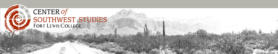
Item C001200303006: Dominguez-Escalante expedition of 1776, copy of map drawn in 1778. Labeled (near upper right of map) in old Spanish as follows: geographic map of the land discovered/ rediscovered in the areas northwest and west of New Mexico, made by Don Bernardo de Mieray Pachecoa, who came in to make his discoveries accompanied by R.T's P.Ps …Francisco Atanasio Domingues and Fr. Silbestre Veles… Al Senor Theodoro de la C…, of the Teutonic Order, commander and general in chief of the … in the year 1778. The legend (in a second dark circle, left of center, shows villas (houses); villages of Indians; ranches and small communities from Spain; groups of Spanish people who were ruined by their enemies; housing of Indians who were friendly to the Spanish; a sign for where we are going, making our daily travels; and watercourses. Below the name for the Rio de las Animas (Animas River) the text mentions the ruins of the large community of the ancient Indians.
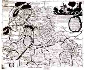
Item C0012007114: Map of
wagon routes in Utah Territory, explored and opened by Capt. J. H. Simpson,
assisted by Lieuts. J. L. K. Smith and H. S.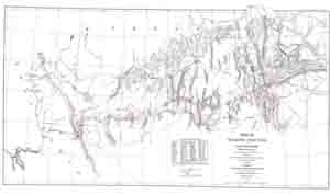 Putnam, and Mr. Henry Engelmann in 1858-59 by authority of Hon. John B. Floyd,
Secretary of War, and under instructions from Bvt. Brig. Gen. A. S. Johnston,
United States Army Corps of Topographical Engineers. Drawn by J. P. Mechlin.
Scale: 1: 1,000,000. Includes a table of geographical positions established by
Capt. Simpson. The Southeast corner of Utah is blank on the map and is simply
described as unexplored. This map was a fold-out in the book, Report of
explorations across the great basin of the territory of Utah for a direct
wagon-route from Camp Floyd to Genoa, in Carson Valley, in 1859, by Captain J.
H. Simpson, Washington, Govt. Printing Office, 1876.
Putnam, and Mr. Henry Engelmann in 1858-59 by authority of Hon. John B. Floyd,
Secretary of War, and under instructions from Bvt. Brig. Gen. A. S. Johnston,
United States Army Corps of Topographical Engineers. Drawn by J. P. Mechlin.
Scale: 1: 1,000,000. Includes a table of geographical positions established by
Capt. Simpson. The Southeast corner of Utah is blank on the map and is simply
described as unexplored. This map was a fold-out in the book, Report of
explorations across the great basin of the territory of Utah for a direct
wagon-route from Camp Floyd to Genoa, in Carson Valley, in 1859, by Captain J.
H. Simpson, Washington, Govt. Printing Office, 1876.
Item C001.01:
Denver & Rio Grande Railroad
right of way and track map of Durango, Colorado,
1937/ by
Arthur Ridgway, for the Denver & Rio Grande Railroad, Fourth Division
(Denver, Colo.) Denver & Rio Grande Railroad map
number Colo. V-17-A/19: Station 3541+84 to Station 3670+03. This
map is itself one section of a seventy-one-foot long by 24-inch high
contiguous map of the Denver & Rio Grande Railroad track and right of way all
the way between the Durango railroad station and the Silverton railroad
station (Accession x2005:02003.004). Due to the size of the entire map,
only this first map portion, of Station 3541+84 to Station 3670+03 (i.e., of
Durango) has been (and can be) digitized.
Colorado,
1937/ by
Arthur Ridgway, for the Denver & Rio Grande Railroad, Fourth Division
(Denver, Colo.) Denver & Rio Grande Railroad map
number Colo. V-17-A/19: Station 3541+84 to Station 3670+03. This
map is itself one section of a seventy-one-foot long by 24-inch high
contiguous map of the Denver & Rio Grande Railroad track and right of way all
the way between the Durango railroad station and the Silverton railroad
station (Accession x2005:02003.004). Due to the size of the entire map,
only this first map portion, of Station 3541+84 to Station 3670+03 (i.e., of
Durango) has been (and can be) digitized.
(See also the Center of Southwest Studies' collections of maps produced by the Rio Grande Southern Railroad [Collection C 006], et al.)
Item 2007:103.002 in the Nina Heald Webber Southwest Colorado collection: American Smelting and Refining Co. smelter map, showing adjacent areas in the city of Durango, including barns, warehouses, sheds, a slaughter house, a rendering house, mills, stock yards, the railroad yards, and a pump house, etc., east/across the Animas River from the smelter and other structures including coke ovens, a dwelling, a barn, scales, and a power house on the same side of the river as the smelter. Denver and Rio Grande Western (D&RGW) tracks are shown in red; Rio Grande Southern (RGS) tracks to Ridgway are shown in green. Undated. Includes a mention of "AFE 2898 - 1952 Retire Tracks." Scale: 1" = 100'. Dimensions: 25" x 33.8".
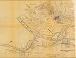
Item C0012005030121:
Lines of communication
between Conejos
and Pagosa Springs, Colorado, January 1878
by the Office
of Chief Engineer, Department of Missouri, Fort Leavenworth, Kansas
(to
view, click on picture on left)
![]() Item
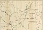
B001QE1N471957:
Item
B001QE1N471957:
Geologic map of the western San
Juan Mountains, Colorado
by Vincent C. Kelley, 1957
(to view,
click on picture on left)
| Item B001QE75P9166:
Physiography and
quaternary geology of the San Juan Mountains, Colorado by Wallace W. Atwood and Kirtley F. Mather, 1932. (to view, click on pictures below) |
|
|
Plate 1: |
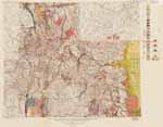 |
|
Plate 2:
|
|
|
Plate 3: |
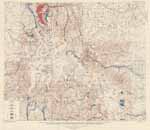 |
Note: this list is limited to 377 of the
geographically-arranged maps; the subject-arranged maps are not yet
described at the item level.
|
Location |
Title |
Date of map |
|
SW 166 Shelf 34.3, Box 2, Folder 1 |
AB&C Property, Durango (Colo.) plats |
1940/1960 |
|
SW 166 Shelf 34.3, Box 4, Folder 3 |
ABC Properties (Durango, Colo.) plat |
1982-06-22 |
|
SW 168 Drawer 2.14, Folder 1 |
Aboriginal history of the Southwest map |
|
|
SW 168 Drawer 2.11, Folder 2 |
Adams County (Colo.) general highway map |
1979-1-1 |
|
SW 168 Drawer 2.18, Folder 1 |
Alaska Native peoples map |
|
|
SW 168 Drawer 2.01, Folder 3 |
Alton C. Dorsett residence (Durango, Colo.) architectural drawings |
1974-08-20 |
|
SW 168 Drawer 2.14, Folder 1 |
Anglo-Mexican and Modern periods of the Southwest map |
|
|
SW 168 Drawer 2.08, Folder |
Animas City (Colo.) map |
1971 |
|
SW 168 Drawer 2.12, Folder 3 |
Animas City (Colo.) map |
1909 |
|
SW 168 Drawer 2.11, Folder 1 |
Apartment building (La Junta, Colo.), architectural blueprints |
1960/1990 |
|
SW 168 Drawer 2.14, Folder 1 |
Archaeology of the Southwest map |
|
|
SW 166 Shelf 34.3, Box 2, Folder 1 |
Arizona and Utah state maps |
1910/1920 |
|
SW 166 Shelf 34.3, Box 6, Folder 2 |
Baltazar Baca and Sons land grant (N.M.) plat |
1878-11-30 |
|
SW 168 Drawer 2.02, Folder 2 |
Bodo Business Ranches (Durango, Colo.) plat |
1978-02 |
|
SW 166 Shelf 34.3, Box 1, Folder 8 |
Bodo Business Ranches (Durango, Colo.) plat |
1983-10-02 |
|
SW 168 Drawer 2.02. Folder 2 |
Bodo Business Ranches (Durango, Colo.) zoning map |
1970-08 |
|
SW 168 Drawer 2.02, Folder 2 |
Bodo Business Ranches, Unit III (Durango, Colo.) plat |
1977-09-21 |
|
SW 166 Shelf 34.3, Box 4, Folder 3 |
Brown Sewing Center (Durango, Colo.) architectural drawing |
1940/1970 |
|
SW 168 Drawer 2.08, Folder ? |
C-137 west central La Plata County, Colorado, map |
1954 |
|
SW 168 Drawer 2.14, Folder 1 |
California ground water map |
1995 |
|
SW 168 Drawer 2.04, Folder 1 |
California Mining District (La Plata Mountains, La Plata County, Colo.) map |
1893-06-21 |
|
SW 168 Drawer 2.01, Folder 2 |
Carleno Business Park (Durango, Colo.), blueprints |
1977 |
|
SW 168 Drawer 2.14, Folder 1 |
Central Rockies map |
1984 |
|
SW 166 Shelf 34.3, Box 4, Folder 1 |
Childers property (School District 9-R, La Plata County, Colo.) plat |
1966-09-27 |
|
SW 166 Shelf 34.3, Box 4, Folder 3 |
Circle K building (Durango, Colo.) ground floor, architectural drawings |
1970-1990 |
|
SW 168 Drawer 2.01, Folder 1 |
Cities of Durango and Animas [City] (Colo.) map |
1910/1940 |
|
SW 166 Shelf 34.3, Box 4, Folder 1 |
City of Durango (Colo.) additions and re-subdivisions map |
1940/1960 |
|
SW 168 Drawer 2.01, Folder 3 |
City of Durango (Colo.) blueprint map |
1950/1960 |
|
SW 166 Shelf 34.3, Box 3, Folder 1 |
City of Durango (Colo.) improvements along the D. & R.G.W. Railroad, map |
|
|
SW 168 Drawer 2.01, Folder 3 |
City of Durango (Colo.) indexed street map |
1970-02 |
|
SW 168 Drawer 2.01, Folder 1 |
City of Durango (Colo.) land use map |
1994/1995 |
|
SW 168 Drawer 2.02, Folder 3 |
City of Durango (Colo.) map |
1982 |
|
SW 168 Drawer 2.01, Folder ? |
City of Durango (Colo.) map |
1974 |
|
SW 168 Drawer 2.02, Folder 3 |
City of Durango (Colo.) map |
1980 |
|
SW 166 Shelf 34.3, Box 4, Folder 1 |
City of Durango (Colo.) precincts map |
1955/1969 |
|
SW 166 Shelf 34.3, Box 4, Folder 1 |
City of Durango (Colo.) street and property maps |
1940/1960 |
|
SW 168 Drawer 2.01, Folder 3 |
City of Durango (Colo.) street map |
1920/1940 |
|
SW 166 Shelf 34.3, Box 6, Folder 1 |
City of Durango (Colo.) streets and lots map |
1948-01 |
|
SW 168 Drawer 2.02, Folder 3 |
City of Durango (Colo.) streets and places of interest map |
1940/1950 |
|
SW 168 Drawer 2.01, Folder 3 |
City of Durango (Colo.) traffic pattern as proposed by the master plan adopted February 1972, map |
1972-07-11 |
|
SW 166 Shelf 34.3, Box 4, Folder 1 |
City of Durango (Colo.) traffic pattern as proposed in the master plan adopted February 1972, map |
1972/02 |
|
SW 168 Drawer 2.01, Folder 4 |
City of Durango (Colo.) zoning map |
1970-05-18 |
|
SW 166 Shelf 34.3, Box 3, Folder 1 |
City of La Junta (Colo.) map |
1962 |
|
SW 168 Drawer 2.02, Folder 1 |
Coal outcrop near Durango (Colo.) map |
1870/1900 |
|
SW 168 Drawer 2.11, Folder 1 |
Coffin's Addition (Cortez, Colo.) map |
|
|
SW 168 Drawer 2.11, Folder 1 |
Colorado drainage map |
1877 |
|
SW 168 Drawer 2.11, Folder 1 |
Colorado highway map |
1970/1980 |
|
SW 168 Drawer 2.11, Folder 1 |
Colorado highway map |
1988 |
|
SW 168 Drawer 2.11, Folder 1 |
Colorado map |
1870/1880 |
|
SW 168 Drawer 2.11, Folder 1 |
Colorado mountain passes and highways |
|
|
SW 168 Drawer 2.11, Folder 1 |
Colorado oil and gas map |
|
|
SW 166 Shelf 34.3, Box 1, Folder 1 |
Colorado plat book |
1900/1930 |
|
SW 166 Shelf 34.3, Box 2, Folder 1 |
Colorado precipitation distribution map |
1950-01 |
|
SW 166 Shelf 34.3, Box 6, Folder 2 |
Colorado River Storage Project map |
|
|
SW 168 Drawer 2.01, Folder 5 |
Colorado State Patrol Microwave Tower on Missionary Ridge (La Plata County, Colo.) plat |
1964-07-01 |
|
SW 166 Shelf 34.3, Box 3, Folder 1 |
Colorado water resource development map |
1975 |
|
SW 166 Shelf 34.3, Box 4, Folder 1 |
Comprehensive plan for La Plata County (Colo.) maps |
1963-04 |
|
SW 166 Shelf 34.3, Box 4, Folder 1 |
Congressional representative districts and precincts of Montezuma County (Colo.) map |
1984-02-21 |
|
SW 168 Drawer 2.12, Folder ? |
Conservation plan map |
1973 |
|
SW 166 Shelf 34.3, Box 1, Folder 9 |
Cortez (Colo.) precincts map |
1964-05-26 |
|
SW 166 Shelf 34.3, Box 4, Folder 5 |
Cripple Creek (Colo.) fire map |
1896-05-20 |
|
SW 168 Drawer 2.07, Folder 3 |
Cunningham Creek-Deep Creek Transmountain Diversion Ditch (San Juan County, Colo.) plat |
1956 |
|
SW 168 Drawer 2.07, Folder 2 |
Dailey Hott extension ditch and enlargement to the Roesler Ditch (Archuleta County, Colo.) map |
1929 |
|
SW 168 Drawer 2.07, Folder 1 |
Delta County (Colo.) map |
1970 |
|
SW 168 Drawer 2.11, Folder 1 |
Dolores (Colo.) townsite, plat |
1891-12 |
|
SW 168 Drawer 2.07, Folder 2 |
Dolores and Montezuma County (Colo.) water resources map |
|
|
SW 168 Drawer 2.07, Folder 2 |
Dolores County (Colo.) general highways maps |
1977 |
|
SW 168 Drawer 2.02, Folder 1 |
Dorsett Resort (Durango, Colo.) plat |
1960/1990 |
|
SW 168 Drawer 2.02, Folder 1 |
Dorsett Resort (Durango, Colo.), section elevation architectural drawings |
1960/1990 |
|
SW 168 Drawer 2.02, Folder 3 |
Durango (Colo.) aerial photograph map |
1973-10-02 |
|
SW 166 Shelf 34.3, Box 4, Folder 3 |
Durango (Colo.) and vicinity map |
1960 |
|
SW 166 Shelf 34.3, Box 5, Folder 8 |
Durango (Colo.) and vicinity township map |
1890/1900 |
|
SW 168 Drawer 2.01, Folder 1 |
Durango (Colo.) city street map |
1940/1950 |
|
SW 168 Drawer 2.01, Folder 3 |
Durango (Colo.) city street map |
1940/1950 |
|
SW 168 Drawer 2.01, Folder ? |
Durango (Colo.) city streets maps |
|
|
SW 168 Drawer 2.01, Folder 4 |
Durango (Colo.) deeds and land acquisitions map |
1881/1952 |
|
SW 168 Drawer 2.02, Folder 1 |
Durango (Colo.) downtown occupancy and parking survey map |
1959-03 |
|
SW 166 Shelf 34.3, Box 4, Folder 1 |
Durango (Colo.) fire insurance map |
1931/04 |
|
SW 166 Shelf 34.3, Box 4, Folder 2 |
Durango (Colo.) fire insurance map |
1904 |
|
SW 166 Shelf 34.3, Box 4, Folder 2 |
Durango (Colo.) fire insurance maps |
1910 |
|
SW 166 Shelf 34.3, Box 4, Folder 2 |
Durango (Colo.) fire insurance maps |
1931-04/1939-01-04 |
|
SW 166 Shelf 34.3, Box 4, Folder 2 |
Durango (Colo.) fire insurance maps |
1904 |
|
SW 168 Drawer 2.01, Folder 5 |
Durango (Colo.) High School plat |
1980/2000 |
|
SW 166 Shelf 34.3, Box 3, Folder 1 |
Durango (Colo.) industrial park, architectural drawing |
|
|
SW 168 Drawer 2.01, Folder 4 |
Durango (Colo.) industrial park, plat |
1967-03-08 |
|
SW 168 Drawer 2.02, Folder 2 |
Durango (Colo.) industrial re-subdiivion plat |
1955-08-22 |
|
SW 168 Drawer 2.01, Folder 4 |
Durango (Colo.) Main Avenue occupancy survey map |
1955-02-15 |
|
SW 166 Shelf 34.3, Box 4, Folder 2 |
Durango (Colo.) major street plan and Town Plaza map |
1959 |
|
SW 168 Drawer 2.01, Folder 4 |
Durango (Colo.) map |
1996 |
|
SW 166 Shelf 34.3, Box 4, Folder 1 |
Durango (Colo.) map |
1960/1980 |
|
SW 168 Drawer 2.02, Folder 3 |
Durango (Colo.) map |
1996 |
|
SW 168 Drawer 2.02, Folder 2 |
Durango (Colo.) map |
1950/1980 |
|
SW 168 Drawer 1.05 |
Durango (Colo.) miscellaneous blueprints |
1960 |
|
SW 168 Drawer 2.01, Folder 4 |
Durango (Colo.) picture map, with directory of businesses and services |
1983 |
|
SW 168 Drawer 2.01, Folder ? |
Durango (Colo.) property lines map |
1982 |
|
SW 166 Shelf 34.3, Box 4, Folder 1 |
Durango (Colo.) street map, compiled by the Engineering Department of the A.& C.R.R. railroad |
1910-03 |
|
SW 168 Drawer 2.04, Folder ? |
Durango (Colo.) tourist maps |
|
|
SW 166 Shelf 34.3, Box 2, Folder 1 |
Durango (Colo.) U.S. Highway 160 road and water line easements map |
|
|
SW 168 Drawer 2.02. Folder 2 |
Durango (Colo.) zoning map |
1973-01-19 |
|
SW 168 Drawer 2.07, Folder 1 |
Durango and Cortez (Colo.) tourist maps, also of Bayfield, Pagosa Lakes, Pagosa Springs, Silverton, and southwestern Colorado |
1996 |
|
SW 168 Drawer 2.02, Folder 1 |
Durango Hills project (Durango, Colo.) plat |
1973-07-24 |
|
SW 168 Drawer 2.02, Folder 1 |
Durango Hills project (Durango, Colo.) survey plat |
1972-04-26 |
|
SW 168 Drawer 2.01, Folder 1 |
Durango Sports World (Durango, Colo.) property lines map |
1982 |
|
SW 168 Drawer 2.02, Folder 3 |
Durango Technical Center (Durango, Colo.) plan map |
1994-04-05 |
|
SW 168 Drawer 2.04, Folder 2 |
Durango West (La Plata County, Colo.) ownership plat |
1965/1970 |
|
SW 168 Drawer 2.04, Folder 2 |
Durango West (La Plata County, Colo.) right of way plat |
1969-04-24 |
|
SW 168 Drawer 2.11, Folder 1 |
Durango, Cortez, La Plata County, Montezuma County (Colo.) streets and roads maps |
1993 |
|
SW 168 Drawer 2.01, Folder 4 |
Durango, Silverton and vicinity (Colo.) souvenir map and guide |
1999/2005 |
|
SW 168 Drawer 2.16, Folder ? |
Durango's living history map |
1999 |
|
SW 168 Drawer 2.16, Folder ? |
Dutton Ditch (Archuleta County, Colo.) map |
1951 |
|
SW 168 Drawer 2.07, Folder 3 |
Dutton Ditch (Archuleta County, Colo.) plat |
1951 |
|
SW 168 Drawer 2.07, Folder 3 |
Eaklor Ditch (Archuleta County, Colo.) map |
1950 |
|
SW 168 Drawer 2.07, Folder 3 |
Eaklor Ditch (Archuleta County, Colo.), enlargement and extension plat |
1960 |
|
SW 166 Shelf 34.3, Box 4, Folder 4 |
Early Colorado historical map |
1935 |
|
SW 168 Drawer 2.02, Folder ? |
Early Colorado historical map |
1949 |
|
SW 166 Shelf 34.3, Box 1, Folder 7 |
Early French map of North America |
1500/1600 |
|
SW 168 Drawer 2.04, Folder 2 |
Ed Larsen property (La Plata County, Colo.) plat |
1976-10-20 |
|
SW 168 Drawer 2.04, Folder 2 |
Ed Larsen property (La Plata County, Colo.) plat |
1976-10-20 |
|
SW 168 Drawer 2.02, Folder 2 |
Edgemont Ranch (Durango, Colo.) sewer system plat |
1970/1980 |
|
SW 166 Shelf 34.3, Box 2, Folder 1 |
Electra Lake Sporting Club (La Plata County, Colo.) map |
1965-06 |
|
SW 166 Shelf 34.3, Box 3, Folder 9 |
Emigh-Wheat Tract, La Plata County (Colo.) plat |
|
|
SW 166 Shelf 34.3, Box 4, Folder 3 |
Enghart Building on North Main Avenue (Durango, Colo.) architectural drawing |
1920/1950 |
|
SW 168 Drawer 2.14, Folder 1 |
Fishlake National Forest (Utah), travel map |
1987 |
|
SW 168 Drawer 2.02, Folder 1 |
Florance Heights Resubdivision (Durango, Colo.) plat |
1971-09-18 |
|
SW 166 Shelf 34.3, Box 2, Folder 1 |
Florida County Road (La Plata County, Colo.) plat |
|
|
SW 168 Drawer 2.04, Folder 2 |
Florida Pines Subdivision (La Plata County, Colo.) plat |
1976-02-10 |
|
SW 166 Shelf 34.3, Box 2, Folder 1 |
Florida River Estates (Durango, Colo.) boundaries map |
|
|
SW 168 Drawer 2.02, Folder 1 |
Florida River Estates (Durango, Colo.) map |
1970/1980 |
|
SW 168 Drawer 2.02, Folder 1 |
Florida River Estates (Durango, Colo.) plat |
1962-07-27 |
|
SW 168 Drawer 2.02, Folder 1 |
Florida River Estates (Durango, Colo.) resubdivision and second subdivision, plat |
1965-01-31 |
|
SW 166 Shelf 34.3, Box 3, Folder 1 |
Florida River Estates (Durango, Colo.) water distribution box, architectural drawing |
1973-04-12 |
|
SW 168 Drawer 2.02, Folder 1 |
Florida River Estates (Durango, Colo.) water system, plat |
1974-09-01 |
|
SW 168 Drawer 2.02, Folder 1 |
Florida River Estates (Durango, Colo.), pump house, architectural drawing |
1986-01-14 |
|
SW 168 Drawer 2.02, Folder 1 |
Florida River Estates Resubdivision (Durango, Colo.) plat |
1982-04-28 |
|
SW 166 Shelf 34.3, Box 4, Folder 1 |
Florida River Estates Resubdivision (Durango, Colo.) plat |
1964-02-23 |
|
SW 168 Drawer 2.02, Folder 1 |
Florida River Estates Resubdivision (Durango, Colo.) plat |
1965-01-11 |
|
SW 168 Drawer 2.02, Folder 1 |
Florida River Estates Resubdivision (Durango, Colo.) water system, plat |
1965-01-11 |
|
SW 166 Shelf 34.3, Box 6, Folder 1 |
Florida River Estates Resubdivision (Durango, Colo.), aerial photograph and plat |
1965-1-11 |
|
SW 166 Shelf 34.3, Box 4, Folder 1 |
Florida River Estates Second Subdivision (Durango, Colo.) plat |
1967-10-31 |
|
SW 168 Drawer 2.02, Folder 2 |
Florida Road sidewalk construction (Durango, Colo.) plat |
1973-03-21 |
|
SW 168 Drawer 2.01, Folder 4 |
Fort Lewis A&M College (Durango, Colo.) pump house, architectural drawing |
1955-09-06 |
|
SW 168 Drawer 2.01, Folder 4 |
Fort Lewis College (Durango, Colo.) tennis courts plat |
1968-06-05 |
|
SW 166 Shelf 34.3, Box 2, Folder 1 |
Fort Lewis Military Reservation (Colo.) township map |
1884-02-29 |
|
SW 166 Shelf 34.3, Box 4, Folder 1 |
Francis Garcia property (Durango, Colo.) plat |
|
|
SW 166 Shelf 34.3, Box 2, Folder 1 |
Ghost towns and jeep roads of the San Juans (Colo.) map |
1973 |
|
SW 166 Shelf 34.3, Box 4, Folder 1 |
Goeglein Gulch property (La Plata County, Colo.) plat |
|
|
SW 166 Shelf 34.3, Box 4, Folder 1 |
Gold King Group Mines (La Plata County, Colo.) map |
1890/1900 |
|
SW 166 Shelf 34.3, Box 3, Folder 1 |
Grand Junction (Colo.) map |
1920/1950 |
|
SW 166 Shelf 34.3, Box 6, Folder 1 |
Gunnison River Dam Sites (Colo.) map |
1934 |
|
SW 168 Drawer 2.01, Folder 4 |
H. D. May property (Durango, Colo.) industrial development engineering, plats |
1957-01-08 |
|
SW 168 Drawer 2.11, Folder 1 |
Hazards map |
1973 |
|
SW 168 Drawer 2.04, Folder 1 |
Hermosa (La Plata County, Colo.) map |
1920/1940 |
|
SW 168 Drawer 2.02, Folder 2 |
Highway construction plan (Durango, Colo.) plat |
1968-11-23 |
|
SW 168 Drawer 2.07, Folder 2 |
Hinsdale County (Colo.) general highway maps |
1977 |
|
SW 166 Shelf 34.3, Box 4, Folder 2 |
Humorous United States map |
1950/1980 |
|
SW 168 Drawer 2.14, Folder 1 |
Indian reservations and Pueblo land grants in northern New Mexico map |
|
|
SW 168 Drawer 2.07, Folder 3 |
Indian Water Resource Development (Colo.) map |
1940/1960 |
|
SW 168 Drawer 2.16, Folder ? |
Indian Water Resource Development map |
|
|
SW 168 Drawer 2.14, Folder 1 |
Initial Spanish exploration of the Southwest, map |
|
|
SW 166 Shelf 34.3, Box 6, Folder 1 |
Island Durango Trailer Park (Durango, Colo.) plat |
1975-11-25 |
|
SW 166 Shelf 34.3, Box 6, Folder 1 |
Island Durango Trailer Park (Durango, Colo.) proposed enlargement, plat |
1969-04-15 |
|
SW 168 Drawer 2.01, Folder 3 |
Island Durango Trailer Park (Riverside Drive, Durango, Colo.) plat |
1960/1980 |
|
SW 166 Shelf 34.3, Box 3, Folder 9 |
Jack Newbold property, La Plata County (Colo.) plat |
1970 |
|
SW 166 Shelf 34.3, Box 6, Folder 1 |
Jeep roads in the San Juan Mountains of Southwest Colorado map |
1965 |
|
SW 168 Drawer 2.07, Folder 1 |
Jeep roads in the San Juan Mountains of Southwest Colorado map |
1950/1980 |
|
SW 166 Shelf 34.3, Box 4, Folder 1 |
Joe E. Childers property (La Plata County, Colo.) plat |
1968-11 |
|
SW 166 Shelf 34.3, Box 4, Folder 1 |
John A. Lee properties maps |
1940/1980 |
|
SW 166 Shelf 34.3, Box 6, Folder 1 |
Kansas map |
1922 |
|
SW 168 Drawer 2.??, Folder ? |
La Junta (Colo.) street map |
1962-11-15 |
|
SW 166 Shelf 34.3, Box 4, Folder 1 |
La Plata (Colo.) Conservation Plan map |
1973-04 |
|
SW 168 Drawer 2.08, Folder ? |
La Plata and Animas Rivers near Durango, Colorado, map |
|
|
SW 166 Shelf 34.3, Box 4, Folder 1 |
La Plata Canyon (La Plata County, Colo.) map |
1920/1940 |
|
SW 168 Drawer 2.09, Folder ? |
La Plata County (Colo.) comprehensive plan |
1962 |
|
SW 168 Drawer 2.04, Folder 2 |
La Plata County (Colo.) general highways map |
1967 |
|
SW 168 Drawer 2.04, Folder 2 |
La Plata County (Colo.) map |
|
|
SW 168 Drawer 2.04, Folder 2 |
La Plata County (Colo.) map |
|
|
SW 168 Drawer 2.04, Folder 2 |
La Plata County (Colo.) map |
|
|
SW 166 Shelf 34.3, Box 3, Folder 1 |
La Plata County (Colo.) map showing road locations by letter and grid number |
|
|
SW 166 Shelf 34.3, Box 4, Folder 1 |
La Plata County (Colo.) precincts map |
1978-02 |
|
SW 168 Drawer 2.05, Folder 1 |
La Plata County (Colo.) property aerial photograph and map |
1982 |
|
SW 168 Drawer 2.05, Folder 1 |
La Plata County (Colo.) property plat |
|
|
SW 166 Shelf 34.3, Box 4, Folder 2 |
La Plata County (Colo.) road map |
1960/1980 |
|
SW 168 Drawer 2.08, Folder ? |
La Plata County (Colo.) sections A - F, map |
|
|
SW 168 Drawer 2.04, Folder 1 |
La Plata County and Montezuma County (Colo.) merchant street guide and index |
1998 |
|
SW 168 Drawer 2.08, Folder ? |
La Plata County portion of State of Colorado land parcel identification system township code |
|
|
SW 168 Drawer 2.04, Folder 1 |
La Plata County, Colorado 20-1 general highway map |
1951 |
|
SW 166 Shelf 34.3, Box 6, Folder 1 |
La Plata County, Colorado 20-2 general highway map |
1951 |
|
SW 168 Drawer 2.11, Folder 1 |
Land ownership, Colorado map |
1973 |
|
SW 168 Drawer 2.18, Folder 1 |
Landforms of the United States map |
1957 |
|
SW 166 Shelf 34.3, Box 3, Folder 1 |
Lightner Creek Bridge approach, Highway 160 (Colo.), architectural drawings |
1979-08-25 |
|
SW 168 Drawer 2.04, Folder 1 |
Lightner Creek Sanitation District (La Plata County, Colo.) plat |
1977-09 |
|
SW 168 Drawer 2.08, Folder ? |
Lines of communication between Conejos and Pagosa Springs, Colorado, map |
1878/01 |
|
SW 168 Drawer 2.16, Folder ? |
Little Navajo Canal (Archuleta County, Colo.) map |
1960 |
|
SW 168 Drawer 2.07, Folder 3 |
Little Navajo Canal (Archuleta County, Colo.) plat |
1960 |
|
SW 168 Drawer 2.01, Folder 3 |
Located Line "L" in the vicinity of, and through Durango (Colo.), blueprint map |
1910-03-14 |
|
SW 168 Drawer 2.01, Folder 5 |
Loma Vista Homes (Durango, Colo.) plat |
1971-06-18 |
|
SW 168 Drawer 2.11, Folder 2 |
Lower East Fork, San Juan Reservoir (N.M.) plat |
1946 |
|
SW 168 Drawer 2.01, Folder 3 |
Main Avenue level (Phase IV) of the north section of the Durango Trade Center (Durango, Colo.), floor plan |
1980/2000 |
|
SW 168 Drawer 2.01, Folder 3 |
Main Mall (Durango, Colo.) 1st and 2nd floor diffuser layouts, architectural drawings |
1976-06-11/1976-11-08 |
|
SW 166 Shelf 34.3, Box 4, Folder 3 |
Main Mall (Durango, Colo.), architectural drawings |
1977-07-21 |
|
SW 168 Drawer 2.14, Folder ? |
Mancos (Colo.) map |
1894 |
|
SW 168 Drawer 2.12, Folder ? |
Mancos (Colo.) map |
|
|
SW 168 Drawer 2.11, Folder 1 |
Mancos (Colo.) plat |
1890-1900 |
|
SW 168 Drawer 2.11, Folder 1 |
Mancos (Colo.) plat |
1903-04-27 |
|
SW 166 Shelf 34.3, Box 4, Folder 1 |
Mancos (Colo.) street plat |
|
|
SW 166 Shelf 34.3, Box 6, Folder 2 |
Mariner's Guide, New World map |
1546 |
|
SW 168 Drawer 2.16, Folder ? |
McPhee Reservoir (Montezuma County, Colo.) map |
1958 |
|
SW 168 Drawer 2.07, Folder 3 |
McPhee Reservoir (Montezuma County, Colo.) map |
1958-01 |
|
SW 168 Drawer 2.11, Folder 2 |
Mesa County (Colo.) general highway maps |
1977 |
|
SW 168 Drawer 2.14, Folder 1 |
Military installations of New Mexico map |
1975 |
|
SW 168 Drawer 2.07, Folder 2 |
Mineral County (Colo.) general highway maps |
1978 |
|
SW 168 Drawer 2.14, Folder 1 |
Missions, presidios and forts of the Southwest map |
|
|
SW 166 Shelf 34.3, Box 4, Folder 1 |
Montezuma County (Colo.) official road map |
1984 |
|
SW 168 Drawer ??, Folder ? |
Moqui Reservation map |
1939 |
|
SW 168 Drawer 2.01, Folder 3 |
Moraine Park, Animas City (Colo.), property of the Durango Railway & Realty Co., blueprint plat |
1903 |
|
SW 168 Drawer 2.01, Folder 5 |
Mountain Shadows Subdivision No. 1 (Durango, Colo.) plat |
1963-08-19 |
|
SW 166 Shelf 34.3, Box 4, Folder 3 |
Mr. and Mrs. Robert Miller residence (Durango, Colo.), architectural drawing |
1930/1950 |
|
SW 168 Drawer 2.04, Folder 2 |
Mrs. Frank Taylor lands (La Plata County, Colo.) plat |
1975-07-24 |
|
SW 166 Shelf 34.3, Box 4, Folder 1 |
Mrs. Sarah Hyde Leyendecker tract survey plat (Colo.) |
1964-05-12 |
|
SW 168 Drawer 2.07, Folder 1 |
Muhovich resubdivision (Monte Vista, Colo.) plat |
1954-04-18 |
|
SW 168 Drawer 2.14 Folder 1 |
National Geographic Southwestern United States map |
1948-12 |
|
SW 168 Drawer 2.14, Folder 1 |
National Geographic Southwestern United States map |
1940-06 |
|
SW 166 Shelf 34.3, Box 6, Folder 2 |
New France (North America) map |
1745 |
|
SW 166 Shelf 34.3, Box 6, Folder 1 |
New Mexico ghost towns map |
1968 |
|
SW 166 Shelf 34.3, Box 6, Folder 2 |
New Netherlands and New England (North America) map |
1635 |
|
SW 166 Shelf 34.3, Box 4, Folder 1 |
New US 160-550 highway approach to Durango (Colo.) map |
1978-09-14 |
|
SW 166 Shelf 34.3, Box 3, Folder 1 |
North America (New France) map |
1600/1700 |
|
SW 166 Shelf 34.3, Box 4, Folder 2 |
North America map |
1842 |
|
SW 166 Shelf 34.3, Box 6, Folder 2 |
North America map |
1826 |
|
SW 166 Shelf 34.3, Box 4, Folder 2 |
North America map |
1600 |
|
SW 166 Shelf 34.3, Box 3, Folder 1 |
Northern Colorado Water Conservancy District - Big Thompson Project map |
1988 |
|
SW 166 Shelf 34.3, Box 4, Folder 2 |
Oil and gas leases on the Dulce anticline (Rio Arriba County, N.M.) |
|
|
SW 166 Shelf 34.3, Box 1, Folder 2 |
Old maps of the Southwest: D'Anville map of 1746 |
1746 |
|
SW 166 Shelf 34.3, Box 1, Folder 6 |
Old maps of the Southwest: Marcy maps of 1850 and 1853 |
1850/1853 |
|
SW 166 Shelf 34.3, Box 1, Folder 3 |
Old maps of the Southwest: Stieler map of 1879, portfolio |
1879 |
|
SW 166 Shelf 34.3, Box 1, Folder 4 |
Old maps of the Southwest: Stieler map of 1885 |
1885 |
|
SW 166 Shelf 34.3, Box 1, Folder 5 |
Old maps of the Southwest: Walker maps of 1849 and 1852 portfolios |
1849/1852 |
|
SW 168 Drawer 2.14, Folder 1 |
Old Santa Fe Trail, Southwest, map |
1913-01-18 |
|
SW 168 Drawer 2.11, Folder 1 |
Pagosa Springs (Colo.) picture map |
1999 |
|
SW 166 Shelf 34.3, Box 4, Folder 1 |
Pagosa Springs (Colo.) plat |
1883 |
|
SW 168 Drawer 2.11, Folder 1 |
Pagosa Springs (Colo.) plat |
1883 |
|
SW 168 Drawer 2.02, Folder ? |
Pagosa Springs, Colorado: land of the healing waters, map |
1999 |
|
SW 168 Drawer 2.07, Folder 2 |
Paradox diversion dam site, San Miguel Project (Colo.) map |
1964 |
|
SW 168 Drawer 2.07, Folder 3 |
Park Ditch (Archuleta County, Colo.) plat |
1953 |
|
SW 166 Shelf 34.3, Box 4, Folder 1 |
Paving area bridge (Durango, Colo.), architectural drawings |
1979-10-15 |
|
SW 168 Drawer 2.04, Folder 1 |
Petroleum ownership in west central La Plata County (Colo.) map |
1958-07-23 |
|
SW 168 Drawer 2.04, Folder 2 |
Pine River Irrigation District (La Plata County, Colo.) map |
1939-04-01 |
|
SW 166 Shelf 34.3, Box 3, Folder 1 |
Pine River Irrigation Project (La Plata County, Colo.) map |
1952-06 |
|
SW 166 Shelf 34.3, Box 4, Folder 1 |
Pine River Reservoir (La Plata County, Colo.) map |
1938-08 |
|
SW 166 Shelf 34.3, Box 2, Folder 1 |
Pine River Valley (La Plata County, Colo.) homstead claims and cash entry tracts map |
1882/1899 |
|
SW 168 Drawer 2.04, Folder 2 |
Pine River where it meets U.S. Highway 160 and a county road, map |
|
|
SW 168 Drawer 2.11, Folder 2 |
Pitkin County (Colo.) general highway maps |
1978 |
|
SW 166 Shelf 34.3, Box 4, Folder 1 |
Placerville (Colo.) town site map |
1909 |
|
SW 168 Drawer 2.02, Folder 1 |
Plaza Valet Center (Durango, Colo.) architectural drawing |
1965-94-24 |
|
SW 168 Drawer 2.14, Folder 1 |
Pony express route, April 3, 1860 - October 24, 1861, map |
1961 |
|
SW 168 Drawer 2.04, Folder 1 |
Portion of State of Colorado Land Identification System in La Plata County (Colo.) map |
|
|
SW 168 Drawer 2.04, Folder 2 |
Properties related to Indian reservations in La Plata County (Colo.) maps |
|
|
SW 168 Drawer 2.04, Folder 2 |
Property known as Sol Kelly Ranch (La Plata County, Colo.) plat |
|
|
SW 166 Shelf 34.3, Box 3, Folder 1 |
Proposed commercial shopping center (Durango, Colo.), architectural drawings |
1958-07-18/1958-11-17 |
|
SW 168 Drawer 2.01, Folder 5 |
Proposed middle school (Durango, Colo.) plat |
1980/2000 |
|
SW 168 Drawer 2.02, Folder 1 |
Public building (Durango, Colo.), architectural drawing |
1900/1930 |
|
SW 168 Drawer 2.07, Folder 2 |
Pueblo County (Colo.) general highway maps |
1977 |
|
SW 166 Shelf 34.3, Box 4, Folder 2 |
Railroad exploration and survey in North America map |
1840/1860 |
|
SW 168 Drawer 2.01, Folder 3 |
Railroad from Durango (Colo.) south to beyond Carbon Junction, blueprint map |
1890/1910 |
|
SW 168 Drawer 2.27, Folder ? |
Red Mesa, Fort Lewis Mesa and vicinity, La Plata County (Colo.) and San Juan County (N.M.) geological map |
1924-12-10 |
|
SW 166 Shelf 34.3, Box 4, Folder 3 |
Residence (Durango, Colo.) architectural drawing |
1930/1950 |
|
SW 166 Shelf 34.3, Box 4, Folder 3 |
Residence (Durango, Colo.), architectural drawing |
1930/1970 |
|
SW 168 Drawer 2.02, Folder 1 |
Residential dwelling (Durango, Colo.) additions to, architectural drawing |
1940/1970 |
|
SW 168 Drawer 2.07, Folder 1 |
Rico (Colo.) plat |
1893-02 |
|
SW 166 Shelf 34.3, Box 6, Folder 1 |
Rico (Colo.) plat |
1893-02 |
|
SW 168 Drawer 2.11, Folder 1 |
Rico (Colo.) plat |
1890-1900 |
|
SW 168 Drawer 2.11, Folder 1 |
Ridgway (Colo.) plat |
1909-03 |
|
SW 166 Shelf 34.3, Box 6, Folder 1 |
Rio Grande Southern Railroad and Trout Lake Dam (Colo.) plat |
1896 |
|
SW 166 Shelf 34.3, Box 3, Folder 1 |
Rio Vista Development Co. (Durango, Colo.), architectural blueprints |
1955-04-27 |
|
SW 168 Drawer 2.01, Folder 4 |
Riverview Development (Durango, Colo.), architectural drawings and financial statements |
1951-03-22 |
|
SW 168 Drawer 2.01, Folder 4 |
Riverview Development Company (Durango, Colo.), architectural drawings and financial statements |
1951-03-22 |
|
SW 166 Shelf 34.3, Box 3, Folder 1 |
Riverview Development Company (Durango, Colo.), survey plat |
1960/1980 |
|
SW 166 Shelf 34.3, Box 4, Folder 3 |
Riverview Drive (Durango, Colo.) houses, plat |
1940/1970 |
|
SW 168 Drawer 2.02, Folder 1 |
Riverview Drive (Durango, Colo.) lot, plat |
1940/1970 |
|
SW 166 Shelf 34.3, Box 3, Folder 2 |
Riverview Heights subdivision (Durango, Colo.), architectural drawings |
1955-04-27 |
|
SW 168 Drawer 2.04, Folder 1 |
Road locations and water projects in La Plata County (Colo.) map |
1960/1980 |
|
SW 168 Drawer 2.11, Folder 1 |
Roadless and undeveloped areas in Colorado map |
1979-01 |
|
SW 166 Shelf 34.3, Box 3, Folder 1 |
Rocky Mountain National-Estes Park (Colo.) map |
1910/1930 |
|
SW 166 Shelf 34.3, Box 4, Folder 2 |
Roebuck Ditch (La Plata County, Colo.) map |
1921 |
|
SW 168 Drawer 2.07, Folder 2 |
Saltado Reservoir (San Miguel County, Colo.) map |
1957 |
|
SW 168 Drawer 2.07, Folder 1 |
San Juan National Forest (Colo.) map and architectural drawings |
1992-08-20 |
|
SW 168 Drawer 2.14, Folder 1 |
San Luis Parc (Colo. and N.M.) map |
1850/1876 |
|
SW 168 Drawer 2.07, Folder 2 |
San Miguel Canal (San Miguel County, Colo.) map |
1957 |
|
SW 168 Drawer 2.16, Folder ? |
San Miguel main canal (San Miguel County, Colo.) map |
1957 |
|
SW 168 Drawer 2.14, Folder ? |
Sand Creek (Colo.) topographic maps |
|
|
SW 168 Drawer 2.11, Folder 1 |
Sand Creek Massacre Site (Colo.) topographical maps |
1982 |
|
SW 168 Drawer 2.01, Folder 1 |
Santa Rita Suburb (Durango, Colo.) plat |
1958 |
|
SW 166 Shelf 34.3, Box 6, Folder 16 |
Sarah Hyde Landecker Tract Survey (Durango, Colo.) plat |
1964/05/12 |
|
SW 168 Drawer 2.02, Folder 1 |
Sarah Levendeckeer home (Durango, Colo.), architectural drawing |
1940/1970 |
|
SW 168 Drawer 2.02, Folder 2 |
Sarah Leyendecker property (Durango, Colo.) plat |
1979-10 |
|
SW 168 Drawer 2.04, Folder 1 |
School districts of La Plata County (Colo.) map |
1936 |
|
SW 166 Shelf 34.3, Box 3, Folder 2 |
Sewage Lift Station (Colo.) architectural drawing |
|
|
SW 166 Shelf 34.3, Box 6, Folder 1 |
Silverton (Colo.) plat |
1890/1910 |
|
SW 168 Drawer 2.04, Folder 2 |
Southern Ute Indian Reservation (Colo.) allotments maps |
|
|
SW 168 Drawer 2.19, Folder ? |
Southern Ute Tribe site development (Ignacio and La Plata County, Colo.) maps, plats, and architectural drawings |
1961 |
|
SW 168 Drawer 2.07, Folder 1 |
Southwest Colorado map |
1950/1980 |
|
SW 166 Shelf 34.3, Box 1, Folder 8 |
Southwest Colorado urban land for sale maps and plats |
|
|
SW 168 Drawer 2.14, Folder 1 |
Southwest road systems map |
|
|
SW 168 Drawer 2.14, Folder 1 |
Southwest, The, map |
1977 |
|
SW 168 Drawer 2.07, Folder 1 |
Southwestern Colorado map |
1893 |
|
SW 168 Drawer 2.??, Folder ? |
Spanish exploration and settlement of the Southwest map |
|
|
SW 168 Drawer 2.01, Folder 4 |
St. Mark's Episcopal Church (Durango, Colo.) parish hall, architectural drawings |
2003-12-01/2003-12-11 |
|
SW 168 Drawer 2.02, Folder ? |
St. Mark's Episcopal Church (Durango, Colo.) proposed remodel architectural plans |
2003 |
|
SW 168 Drawer 2.11, Folder 1 |
State of Colorado highway map |
1970/1980 |
|
SW 168 Drawer 2.11, Folder 1 |
State of Colorado map |
1957 |
|
SW 168 Drawer 2.04, Folder 1 |
State of New Mexico map |
1967 |
|
SW 168 Drawer 2.07, Folder 2 |
Stone Cabin Reservoir site, San Miguel Project (Colo.) map |
1952 |
|
SW 166 Shelf 34.3, Box 4, Folder 2 |
Taos (N.M.) historical map |
1992/1993 |
|
SW 166 Shelf 34.3, Box 4, Folder 2 |
Taos area of New Mexico map |
|
|
SW 168 Drawer 2.07, Folder 1 |
Telluride (Colo.) plat |
1894-03-01 |
|
SW 166 Shelf 34.3, Box 4, Folder 4 |
Territory of the United States west of the Mississippi River, general topographical map |
1869/1874 |
|
SW 168 Drawer 2.02, Folder 2 |
Town of Ignacio (Colo.) land use and building inventory map |
1976 |
|
SW 168 Drawer 2.07, Folder 1 |
Town site of Mancos (Colo.) plat |
1891 |
|
SW 166 Shelf 34.3, Box 4, Folder 3 |
Townsend apartments (Durango, Colo.), architectural drawing |
1930/1970 |
|
SW 166 Shelf 34.3, Box 4, Folder 4 |
Township 34 North, Range 9 West of the New Mexico Principal Meridian, in La Plata County (Colo.), survey map |
1876-10-04/1880-06-05 |
|
SW 166 Shelf 34.3, Box 4. Folder 4 |
Township 34 North, Range 9 West of the New Mexico Principal Meridian, in La Plata County (Colo.), survey map |
1880-10-13/1883-01-17 |
|
SW 166 Shelf 34.3, Box 4, Folder 1 |
Township 35 North, Range 8 West of the New Mexico Principal Meridian, in La Plata County (Colo.) plat |
1959-05/1959-06 |
|
SW 168 Drawer 2.02, Folder 1 |
Township 35 North, Range 8 West of the New Mexico Principal Meridian, in La Plata County (Colo.), survey map |
1876-10-04/1877-08-29 |
|
SW 166 Shelf 34.3, Box 4, Folder 1 |
Township 35 North, Range 9 West of the New Mexico Principal Meridian, in La Plata County (Colo.) map |
1883-11-13 |
|
SW 166 Shelf 34.3, Box 2, Folder 1 |
Township 35 North, Range 9 West, in La Plata County (Colo.) plat |
1964-08-25 |
|
SW 168 Drawer 2.04, Folder 1 |
Township and ranges of La Plata County (Colo.) map |
|
|
SW 168 Drawer 2.04, Folder 1 |
Township, range and section boundaries, Section A, La Plata County (Colo.) map |
1940/1960 |
|
SW 168 Drawer 2.04, Folder 1 |
Township, range and section boundaries, Section B, La Plata County (Colo.) map |
1940/1960 |
|
SW 168 Drawer 2.04, Folder 1 |
Township, range and section boundaries, Section C, La Plata County (Colo.) map |
1940/1960 |
|
SW 168 Drawer 2.04, Folder 1 |
Township, range and section boundaries, Section D, La Plata County (Colo.) map |
1940/1960 |
|
SW 168 Drawer 2.04, Folder 1 |
Township, range and section boundaries, Section E, La Plata County (Colo.) map |
1940/1960 |
|
SW 168 Drawer 2.04, Folder 1 |
Township, range and section boundaries, Section F, La Plata County (Colo.) map |
1940/1960 |
|
SW 166 Shelf 34.3, Box 4, Folder 4 |
Townships 34 1/2 and 35 North, Range 3 West of the New Mexico Principal Meridian, (Colo.), survey map |
1891-05-02/1891-12-22 |
|
SW 166 Shelf 34.3, Box 4, Folder 1 |
Townships 34 1/2 and 35 North, Range 9 West, La Plata County (Colo.) map |
1891-05 |
|
SW 168 Drawer 2.16, Folder ? |
Trout Lake Dam (Colo.), architectural drawing |
1912 |
|
SW 166 Shelf 34.3, Box 4, Folder 2 |
Trout Lake Dam Spillway (Colo.), architectural drawing |
1912-06-19 |
|
SW 168 Drawer 2.18, Folder 2 |
U.S. Civil War: Charleston Harbor (Va.) map |
1865 |
|
SW 168 Drawer 2.18, Folder 2 |
U.S. Civil War: City of Richmond (Va.) map |
1964 |
|
SW 168 Drawer 2.18, Folder 2 |
U.S. Civil War: Fort Fisher attack plan map |
1865 |
|
SW 168 Drawer 2.18, Folder 2 |
U.S. Civil War: Fort Fisher sketches |
1865 |
|
SW 168 Drawer 2.18, Folder 2 |
U.S. Civil War: Fort Hindman, Arkansas, map |
1863 |
|
SW 168 Drawer 2.14, Folder 2 |
U.S. Civil War: Fort Jackson plat |
1862 |
|
SW 168 Drawer 2.18, Folder 1 |
U.S. Civil War: Grand Gulf, Mississippi, map |
1863 |
|
SW 168 Drawer 2.18, Folder 2 |
U.S. Civil War: Grand Gulf, Mississippi, map |
1864 |
|
SW 168 Drawer 2.18, Folder 2 |
U.S. Civil War: Louisiana battlefield maps |
1864 |
|
SW 168 Drawer 2.18, Folder 2 |
U.S. Civil War: Manassas Junction (Va.) plat |
1862-04 |
|
SW 168 Drawer 2.18, Folder 2 |
U.S. Civil War: map |
1864/1865 |
|
SW 168 Drawer 2.18, Folder 2 |
U.S. Civil War: Mississippi River reconnaissance map |
1862 |
|
SW 168 Drawer 2.18, Folder 2 |
U.S. Civil War: Northern Florida map |
1964 |
|
SW 168 Drawer 2.18, Folder 2 |
U.S. Civil War: Savannah (Ga.) map |
1864 |
|
SW 168 Drawer 2.18, Folder 2 |
U.S. Civil War: South Carolina and Georgia seacoast map |
1861-12-01 |
|
SW 168 Drawer 2.18, Folder 2 |
U.S. Civil War: southeastern Virginia military map |
1864 |
|
SW 166 Shelf 34.3, Box 6, Folder 2 |
United States Far West map |
1984 |
|
SW 168 Drawer 2.18, Folder 1 |
United States federal lands map |
1982 |
|
SW 168 Drawer 2.18, Folder 1 |
United States historical map |
1953 |
|
SW 166 Shelf 34.3, Box 6, Folder 2 |
United States map |
1784 |
|
SW 168 Drawer 2.18, Folder 1 |
United States physical landscape and federal lands map |
1996 |
|
SW 168 Drawer 2.18, Folder 1 |
United States territorial growth map |
1987 |
|
SW 166 Shelf 34.3, Box 3, Folder 1 |
Vallecito Dam construction progress (La Plata County, Colo.), architectural drawing |
1930-08-09 |
|
SW 168 Drawer 2.04, Folder 2 |
Vallecito Damsite #2 (La Plata County, Colo.) plat |
1930/1940 |
|
SW 168 Drawer 2.04, Folder 2 |
Vallecito Reservoir (La Plata County, Colo.) plat |
1930/1950 |
|
SW 168 Drawer 2.04, Folder 2 |
Vallecito Reservoir (La Plata County, Colo.) plat |
1948-01-28 |
|
SW 168 Drawer 2.04, Folder 2 |
Vallecito Reservoir (La Plata County, Colo.), land ownership plat |
1979-05-22 |
|
SW 166 Shelf 34.3, Box 6, Folder 1 |
Vallecito Reservoir (La Plata County, Colo.), master plan map |
1959-04-25 |
|
SW 166 Shelf 34.3, Box 4, Folder 1 |
Vallecito Reservoir area (La Plata County, Colo.) plat |
1965-12-13 |
|
SW 168 Drawer 2.02, Folder 2 |
W. D. Ewing lands (Durango, Colo.) plat |
1900/1920 |
|
SW 168 Drawer 2.04, Folder 3 |
Wallace Service Road (La Plata County, Colo.) plat |
|
|
SW 168 Drawer 2.07, Folder 1 |
Water District No. 3 ditch and reservoir systems, diagram |
1972 |
|
SW 168 Drawer 2.01, Folder 3 |
Water mains (Durango, Colo.) map |
1959/1963 |
|
SW 168 Drawer 2.08, Folder 1 |
West Fork Canal (Mineral and Archuleta Counties, Colo.) plat |
1960 |
|
SW 166 Shelf 34.3, Box 4, Folder 2 |
West Fork San Juan Reservoir, Rio Grande Joint Investigation (Colo.) map |
1937 |
|
SW 168 Drawer 2.??, Folder ? |
Western Grant County (N.M.), geologic map |
1964 |
|
SW 166 Shelf 34.3, Box 1, Folder 9 |
Westward to the Pacific and war with Mexico, U.S.A., including the Southwest, map |
1853 |
|
SW 166 Shelf 34.3, Box 6, Folder 2 |
World map |
1667 |
|
SW 168 Drawer 2.14, Folder ? |
World, The: Van Der Griten's spherical projection, compliments of the Schaefer Tent and Awning Company (Denver, Colo.) map |
1906 |
|
SW 166 Shelf 34.3, Box 6, Folder 1 |
World, U.S., Panama Canal and Colorado, maps |
1900/1910 |
|
SW 168 Drawer 2.07. Folder 3 |
Yellow Jacket Canal (Montezuma County, Colo.) plat |
1958 |
For more information:
- For details about maps in this collection that have been cataloged at the item level, please ask the archival staff at the Delaney Library to check in the in-house swmaps.mdb database.
- For additional guides to special collections relating to maps of the Southwest, see the Center's Pathfinder of Southwest Geology.
Doing your own research: This description of a portion of the collections at the Fort Lewis College Center of Southwest Studies is provided to inform interested parties about the nature and depth of the repository's collections. It cannot serve as a substitute for a visit to the repository for those with substantial research interests in the collections.
This collection is located at the Center of Southwest Studies on the campus of Fort Lewis College. Researchers wanting more information about using this material at the Delaney Southwest Research Library at the Center may email the archivist at archives@fortlewis.edu or click here to use our E-mail Reference Request Form (or phone the archivist at 970/247-7126). The Center does not have a budget for outgoing long-distance phone calls to answer reference requests, so please email if you wish to receive a response from the Center. To request reproductions/copies, click here for instructions.